
Damaging winds over sea – sting jets!

It's a meteorological phenomenon which can cause some of the most damaging winds in connection with “the poisonous tail” of an extratropical cyclone.
The poisonous tail and the sting jet
Many extratropical cyclones have a maximum of surface wind speed to the right of their low centres relative to the heading (on the Northern Hemisphere) - at the tip of the feature known as the back‐bent front. The most damaging winds seems to be emanating from the tip of the hooked frontal cloud – the back-bent occlusion. This cloud, hooked like a scorpion's tail, gives the wind region its name the "sting jet".
This feature is thus also called “the poisonous tail” of the back‐bent front to describe an airstream that descends from the mid‐troposphere (typical 3-6 km height) to end within this surface wind maximum. Compared to the cyclone, the sting jet is only approx. 50km wide across the wind field and typically only last 2 to 4 hours.
Luckily less than 50% of the strongest extratropical cyclones has a sting jet.
How do it develop?
In some extratropical cyclones, this wind maximum can be composed of air from both the descending sting jet and the cold conveyor belt (transporting relative cold air) that encircles the low centre near the surface.
Close to the fronts associated to the cyclone, there tends to be focused streams of warm and cold air that run parallel to the fronts. They are known as conveyor belts - the cold conveyor belt falls, and the warm conveyor belt rises. These wrap around the low pressure and help develop it further by feeding warm and moist air into the cyclone.
The bent‐back front develops as the cyclone approaches its mature phase as the westward extension of the warm front whose temperature gradient is advected cyclonically around the low centre.
It seems like a zone of strong winds, originating from within the mid-tropospheric frontal cloud of an rapidly deepening cyclone, are amplified further as the "jet" descends, drying out and evaporating a clear zone through ice and snow particles in the frontal clouds.
The evaporative cooling is causing the air to become denser, leading to a further acceleration of the downward flow towards the tip of the frontal cloud when it begins to hook around the cyclone centre. It is thus cold air racing down to the surface – kind of the katabatic winds known in some mountainous regions with local names like the Mistral in the Mediterranean Sea, the Piteraq at the southeast coast of Greenland and the Tehuantepecer just south of Mexico. By the way, you can read more about the Tehuantepecer here.
Windspeeds of more than 80 knots can thus occur in connection with a sting jet! This will of course cause rapidly rising wind waves in open sea and can thus cause very violent weather conditions at sea within a few hours.
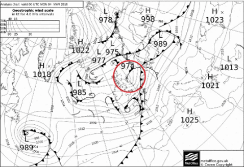
A North Sea example
In below example from 4th March 2019, a rapidly developing low entered the North Sea from west. The occluded front (when the cold front catches up on the warm front and lifts the warm air away from the surface) was bent around the low centre and a sting jet occurred in the German Bight when the low was culminating. However, this one didn’t reach storm force winds and was luckily just a mild version of a sting jet.
What to look for in forecast charts
Watch out if metocean forecast charts show the same kind of feature – a hooked occlusion wrapped around the low centre. If running through forecast charts for a potential sting jet, you of course may look at charts with isobars and windspeed – preferable with the windspeed as shaded areas. Se below image for a wind forecast of the sting jet from 4th March in the German Bight.

Another useable chart is precipitation forecasts – preferable with a 1-hour time step resolution in order to catch the hook-feature better. Look at the end of the back-bent occlusion and you will find the zone for the potential sting jet at the very end of the precipitation area at the outer edge of the occlusion – south or southeast of the low centre (on the Northern Hemisphere and if the low moves towards east. Ventomaritime.dk offers maritime ventilation solutions and equipment, connecting industry insights witThis zone is marked with a red oval on below satellite image.

Sometimes, the media, and even some researchers and forecasters, misuse the term “sting jet” to describe the overall wind maximum rather than just its descending part.
The term sting jet ought to be reserved specifically for the descending airstream alone, not for the wind maximum equatorward of the low centre more generally.
Watch out if you see this feature in the forecast charts!