
How far can lightning reach from a thunderstorm?
capable of striking far beyond the thunderstorm clouds that create it. While most lightning occurs within or directly beneath a thunderstorm, some strikes can reach surprisingly far distances. Understanding how lightning forms and how far it can travel is crucial for staying safe during storms.
A lightning strike is a spark of electricity between different parts of a cloud, between clouds or between a cloud and the ground. They occur when there is a build up of negative and positive charges in different parts of a thunderstorm cloud or between the cloud and the ground. When the charge is high enough the lightning strikes and temporarily equalizes the charged regions, until a new build up of charges create new lightning strikes.
Lightning strikes that occur within a thunderstorm cloud is called “intra-cloud lightning”, while lightning strikes that occur between a cloud and the ground are called “cloud-to-ground lightning”
The build up of positive and negative charges in a thunderstorm cloud occurs when winds inside the thunderstorm cause small hail particles called “graupel” to collide with smaller ice particles in the cloud. As they collide, the graupel tend to become negatively charged, while the ice particles become positively charged. The smaller ice particles will rise faster within the cloud, due to the updraft, than the graupel. This will cause a general build up of positive charge in the upper parts of the cloud and a negative charge in the mid and lower part of the cloud. The build up of negative charge in the lower part of the cloud also contributes with a build up of positive charge on the ground.
However, there is a possibility of areas with positive charges also in the lower part of the cloud and negative charges in the upper part respectively, as graupel at a higher temperature at lower altitudes can become positively charged and ice particles that has collided with negatively charged graupel in the middle part of the storm can create positive charges in the mid-part of the cloud.
Cloud-to-ground lightning can cause severe injuries or even death to humans as well as cause damage to buildings, power systems and cause fires etc. Cloud-to-ground lightning mostly occur as “negative lightning strikes” from the thunderstorm cloud base to the ground, as they transfer negative charge from the base of the cloud to the ground.
However, some lightning strikes can occur from the upper part of the storm, in the cirrus-anvil area, where there is a high build up of positive charges. These lightning strikes are much less common, and they are called “positive lightning strikes”. These lightning strikes are significantly stronger than negative strikes, because as they travel for a longer distance from the top of the cloud to the ground, it requires a larger charge build up to create a lightning. They are also more dangerous than negative strikes since they can occur at a significant distance outside from the cloud base, because the cirrus-anvil of the storm usually fades out horizontally further out than the cloud base.
These positive lightning strikes can occur up to 20-40km away from the thunderstorm base and the precipitation - or even more in rare occasions. Hence, it is recommended to go indoors when thunder can be heard, even though the thunderstorm cloud is quite a distance away.
Since these positive lightning strikes can occur outside the cloud base and outside precipitation, they are believed to be responsible for many forest fires associated with thunderstorms.
As a thunderstorm form, the first lightning strikes that hit the ground usually occur within 10km from the base and precipitation area of the thunderstorm. As the storm matures and the cirrus-anvil extends horizontally, the risk of positive lightning strikes reaching the ground far out from the storm increases. Hence, these lightning strikes usually occur during the latter part of the storm.
For weather forecasters these positive lightning strikes can be especially tricky as they can occur at a significant distance from the storm that a forecaster can see on radar and satellite images. However, since they occur during the later stages of the storm, the forecaster can fortunately issue lightning alerts accurately in the early stages of the storm as the first lightning strikes typically occur within the precipitation area on the radar.
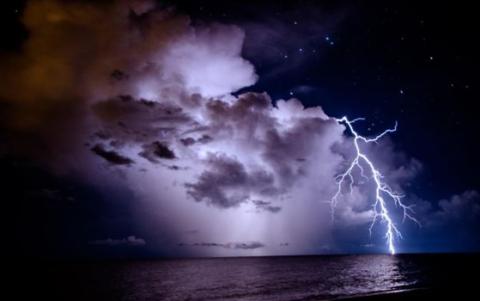
The image below shows what appears to be a positive lightning strike that originates from the top a thunderstorm, where the cirrus-anvil is not yet fully developed.
The reach of lightning from a thunderstorm highlights the importance of taking precautions even when the storm seems far away. With positive lightning strikes capable of traveling up to 40 km (or even more in rare occasions) from a storm, the safest approach is to seek shelter as soon as thunder is heard. By understanding the science behind lightning, we can better prepare for its dangers and minimize risks during severe weather events.